Salvaging a survivable climate one Mahurangi Harbour at a time
Dedicated to helping light the fuse of a democratic Great Mobilisation
Te Muri access dictated drop-in location
author Cimino published 20210703
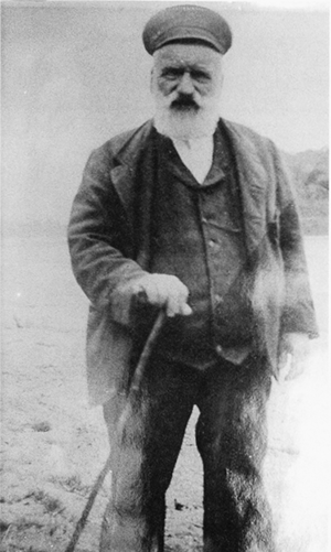
Patron of the Mahurangi Heads West School: As chairman of Mahurangi Heads District School, at Schoolhouse Bay, Scotts Landing, John Darrach, in his late 60s, wrote repeatedly to the Board of Education, urging the establishment of a school at Mahurangi West, concerned of the danger to the pupils rowing across the Mahurangi Harbour to his school. He reported that there were 23 Māori and 14 Pākehā children between the ages of 5 and 15 who would benefit from a school at Mahurangi West.
image Warkworth Museum
Was it not for John Darrach’s 1880s activism, Saturday’s coffee-and-croissants drop-in day, in Mahurangi West’s former school, would have been held in Sullivans Bay.
John Darrach was so exercised about the danger to the 23 Māori and 14 Pākehā children living at school-less Mahurangi West, when many of those rowed themselves across the harbour to Schoolhouse Bay, and back, that he vetoed Board of Education interest in a potential Sullivans Bay/Ōtarawao site.
On the face of it, Sullivans Bay was the entirely reasonable location for Mahurangi West’s first formal school. There was no Mahurangi West Road, only road reserved for what still in the 1970s was called Mahurangi Heads West Roadwhen it commenced as a sideroad of Pukapuka Road. It was subsequently renamed Mahurangi West Road, and extended to the highway, long after that route had become the dominant one. The only all-weather access for the entire Mahurangi community was by water. But death by drowning—particularly from open boats, and in a population where very few were taught to swim to save themselves—stalked maritime people. It was John Darrach’s persistence that succeeded in addressing the unintended consequence of the only Mahurangi Harbour school, the one he was chairman of, being situated on the eastern side of the harbour:
…and besides the ferry for six months past has been conducted by two little boys altogether unfit for the purpose—although they are exceedingly smart yet it is not safe to trust them with their own lives in a dinghy 18 feet long, 3 feet wide and only 17 inches in depth crossing a river …. And at times, they have 8 or 10 little ones no bigger than themselves…
In all probability—from the dimensions cited—what Darrach was describing was known locally as a Mahurangi punt, but used the word dinghy , judging it to be a term more familiar to the board members. If it was indeed a flat-bottomed Mahurangi punt, the young students would no doubt have been acutely aware of how diligent they needed to be in promptly bailing out any water shipped—free surface effect and a flat bottom being notorious for sudden, catastrophic loss of stability.
In the event, land for the school was gifted by the sons of another famous—but far less prolific—Mahurangi boatbuilder, Thomas Scott. George Scott farmed the land and lived at Scotts Point—more properly, Ōpaheke—the bay named for its southern headland, immediately up-harbour from Ōpahi. Although the site gifted was more than a mile and a half’s horse ride from their own farmhouse, it had the virtue of being accessible to the Māori children of Te Muri, without exposure to the clear and present hazards of boating.
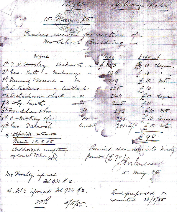
Seriously overqualified for the task, shipwright-turned-farmer George Scott also bid to build the single-classroom school. However, in the inflexible tender process that ensued, his was bested by £5, by the £185 quote of a Warkworth builder. Ironically, before the school could be opened in 1886, the Māori population of Te Muri had relocated to whenua in Northland, leaving the balance of the pupils a muddy slog to reach their local school. Later, some on the roll had to undertake a launch journey, even before their slog.
Triumph of the Mean-Minded and Inflexible: Second lowest tender, by the tantalising close margin of £5, was that of ‘Geo. Scott’, who had donated school’s two-acre site. George Scott’s consolation, no doubt, was that five of his children, more than a fifth of the inaugural roll, would immediately benefit from the new school.
image Archives New Zealand
Fast forward to 1986, and the sight of a geotechnical drilling rig in Te Muri Estuary alerted locals to the Auckland Regional Authority’s plans for a road bridge connecting Ngārewa Drive to parking for 4000 cars adjacent Te Muri Beach. Some, doubtless, were motivated by largely selfish concerns, but most fully appreciated that the regional parkland at Te Muri had been taken, against the heartfelt wishes of the owners, for the greater public good. There was immediate agreement that it was up to the locals to convince the Auckland Regional Authority that reasonable public access could indeed be provided, but by foot. But not just the easy bit, a boardwalk and footbridge across Te Muri Estuary, but a bold new coastal trail, with a lofty, yacht-mast-clearing footbridge, across the Pūhoi Rivermouth.
The campaign was a participatory-democracy triumph, and the plans for the concrete road bridge across Te Muri Estuary were binned. Regional parks staff policymakers, however, saw it as yet another example of the nimbyism that constantly dogs council decisions. Despite the community pleading for progress on the agreed Te Muri Crossing, more than two decades later, as the sun was setting on the Auckland Regional Council, and it purchased its 383-hectare hinterland, all institutional knowledge of the plan to access Te Muri primarily by Mahurangi Coastal Trail had long since been lost.
Saving the sense of splendid isolation afforded by Te Muri a second time, was much harder than the first. The same strategy of presenting a fully argued alternative failed to divert the regional parks policy planners from their mind-set that only by catering the parking of thousands of private-light-vehicles, close by Te Muri Beach, could the 1973 compulsory acquisition, and subsequent $15 million 2010 purchase, be justified. First time around, the battle was won in the first, citizens-advisory-group phase. In 2015, that, crucially constructive, pre-Resource Management Act phase, had long been discarded in favour of a far more legalistic, two-phase one. So, despite two phases and 523 submissions thunderously in favour of private-light-vehicle-free Te Muri, the Draft Regional Parks Management Plan – Te Muri Variation steadfastly adhered to parking at scale, at Te Muri Beach. According to one source, it wasn’t the passion or arguments of the local and regional community devotees of Te Muri that caused the last-minute reprieve, but Auckland Transport’s advice that, aside from the eye-watering high likely cost of upgrading road access to the beach, particularly the Hungry Creek Road section, the work was not on even any long-term scheduled plan of capital expenditure.
Nor should such works ever be. The imperative for immediate climate action mobilisation cannot be plausibly disputed. Even as the 1980s threat to Te Muri was being sent off, former research-scientist Prime Minister Margaret Thatcher was warning:
For generations, we have assumed that the efforts of mankind would leave the fundamental equilibrium of the world's systems and atmosphere stable. But it is possible that with all these enormous changes (population, agricultural, use of fossil fuels) concentrated into such a short period of time, we have unwittingly begun a massive experiment with the system of this planet itself.
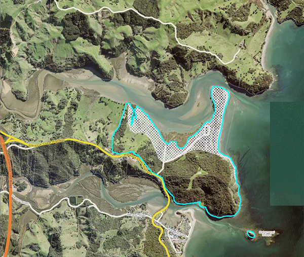
Wenderholm Regional Parking Underwater: When Wenderholm, the first of 26 regional parks acquired between 1965 and 2010, was purchased, it was entirely reasonable to see private-light-vehicle ownership as the healthy default for every New Zealand family. The woeful, unintended consequence is that prime, at-sea-level regional parkland, much of it devoted to parking private-light-vehicles will be being progressively inundated, as the coastal regional parks celebrate their first 100 years. Shown here is regional parkland at Wenderholm lost from 1-metre sea-level rise. Implied, but of course not acknowledged, is that the coastal terraces of Te Muri and Waiwera immediately to the north and south of Wenderholm, and Hatfields and Ōrewa immediately south of this map, are likewise doomed to inundation.
map Auckland Council
In its section titled Climate Change and Regional Parks, the 2020 discussion document that accompanied the invitation to provide phase-1 input to the regional parks management plan review, displayed, as its first non-generic graphic:
Wenderholm Regional Park showing land lost from a 1m sea-levelcouldn’t refrain from inserting at least one of the hyphens omitted! rise
The fact that that area is the entirety of land used for picnicking, camping and parking at present, should signal that the new 10-year plan will take greenhouse-gas emissions entirely seriously. Given that, at present, almost 100% of regional park visitor access is via private-light-vehicle, the shift to rendering the parks readily accessible via public transport needs to be profound, and prompt. Many, of course, will imagine that there is no problem an electric vehicle wouldn’t fix, but to believe that is little like believing that building more 3-br-brick-and-tiles, or monolithic-clads, will fix Auckland’s housing affordability.
Both Long Bay and Wenderholm regional parks are dead-sitters to be primarily public-transport accessed. Wenderholm Regional Park, however, has the additional cachet of providing Aucklanders were their first point of access to both Te Araroa, the national walkway, and to the Waiwera to Waipū Coastal Walkwaystill mostly known by the far less imaginative Pūhoi to Pākiri alliteration. As the Northern Busway has amply demonstrated, bus transport is patronised by more than the impoverished when it provides the superior service. Just one experience of sailing by barely moving bumper-to-bumper motorway traffic is generally all takes to convince most regular or sporadic commuters that taking a private-light-vehicle into the central business district is distinctly a mug’s game, where it can be avoided.
The regional parks access fix is ridiculously easy. Arrivals by public transport are dropped speed-bump-free at the beach. All other vehicles, excepting those conveying people with limited mobility, pay for their parking, well back from the prime recreation parkland. If there is no such detail in the Draft Regional Parks Management Plan released this year, the plan is not climate-emergency-fit-for-purpose. But, and this is the direct responsibility of the Mahurangi Coastal Trail Trust, there needs to be provision for developing the Mahurangi Coastal Trail in a manner that will drive public transport uptake, rather than generate additional vehicle movements on Mahurangi West Road and Ngārewa Drive. Regardless of how overblown some of the suggested impacts of those additional vehicle movements might be—one concrete truck per week would likely do more road damage than one hundredsuvs—it would be perverse to stage the development of the Mahurangi Coastal Trail in the manner most likely to increase private-light-vehicle dependency, rather than the reverse.
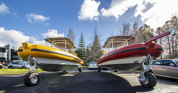
Seriously Unexplored Seriously Elegant Option: Arriving too late to be seriously explored as part of the 2015 Te Muri variation to regional parks management plan process, this seriously uncostedthe motorway-cost-metre-rate estimate of an Auckland Council officer still has fellow coastal engineers perplexed, six years on, elegant option for crossing Pūhoi Estuary, or some similar long-term solution, is clearly needed. Fortunately, the Mahurangi Coastal Trail need not wait for infrastructure on this scale to be designed, consented, and funded, but could be in operation for a tenth of the cost, using an off-the-showroom-floor amphibian such as the 9-metre, 11-seater + skipper Sealegs Hydrasol rib, needed, in any event, for the Mahurangi West – Scotts Landing leg.
rendering Littoralis Landscape Architecture | drone image Majorlook Productions
Fortunately, to stage the coastal trail south to north doesn’t require Te Muri Crossing to be shelved. A virtually off-the-shelf solution is available that would see a ferry service across the Pūhoi River and the Mahurangi Harbour. There are various offerings internationally, but the best is probably the proudly-designed-and-manufactured-in-Tāmaki-Makaurau Sealegs. The Sealegs iteration seemingly most appropriate for the opening up of the Mahurangi Coastal Trail is the 9-metre, 11-seater+skipper Hydrasol rib. The first few years that the Mahurangi Coastal Trail is in use, unless built end-to-end as part of a government-funded $100 million or more Waiwera to Waipū Coastal Walkway, will see use mostly by organised groups. One vessel is all that is needed for such groups to bus to Waiwera, walk to Wenderholm, ferry to Te Muri, walk to Sullivans Bay, and ferry to Scotts Landing or the Mahurangi Peninsula. Because an amphibian-based river and harbour crossing solution requires zero built foreshore infrastructure, its consenting process could readily be concurrent with that of Te Muri Crossing, which, thanks to New Zealand’s 30-year resource-management misadventure, is only now nearing that milestone.
Review of a 10-year Auckland Regional Parks management plan, covering 28 individual parks is a mammoth undertaking. There is ample prior evidence of the inherent danger of the process constraining good policy making, and even when the entire process is focussed on one park. The variation necessitated by the purchase of the 383-hectareTe Muri hinterland is the prime, proximate example. Regional parks planners undertook the variation process with road access to whenua adjacent Te Muri Beach via Hungry Creek Road as a given. Even at the 2015 community drop-in, in the shearing shed at Te Muri, locals were lectured that private-light-vehicle road access was a given. Generally, once a draft regional parks management plan is released, few substantive changes are made to it. Te Muri was different. The following year, belated appreciation by the policy makers that road access, even in the medium term, was unavailable caused a hasty rethink. No backup plan had been prepared and shared, and the access policy that appeared in the final plan—adopted on 14 February 2017—was incoherent.
Rather than a Red and a Yellow, Perhaps Two in Maersk Blue: For perhaps a tenth of the cost of Pūhoi River footbridge with opening span, an out-of-the-showroom amphibian such as the 9-metre, 11-seater+skipper Sealegs Hydrasol rib could be deployed until demand justified a crossing available 365 days of the year. In any event—short of some civic-minded Mahurangi West coastal property holder spontaneously providing a ferry landing site—an amphibian is the only means of establishing a cross-harbour ferry service.
image Sealegs International
Rather than bank the tens of millions of dollars saved by not building the road access that was so determinedly and consistently opposed, the policy writers retained the most expensive and problematic part—upgrading Hungry Creek Road in order that it could be safely used by everybody from beach-bound Pūhoi children, to cyclists, to equestrians, to horse-float-towing suv owners, to Te Araroa walkers. As the Pūhoi Forum pointed out even before 2015, that the place to park horse floats is beneath the motorway. There is nothing a horse enjoys more than a good climb at the beginning of a ride. The council’s main means of Te Muri visitor-access having been side-lined, in any fit-for-purpose planning, should have triggered a process reset. Neither the deferred Hungry Creek Road access nor the green-lighted Ngārewa Drive access were wholesome initial entry points. Access via Ngārewa Drive, unless it was accompanied by comprehensive public transport, was guaranteed to generate additional private-light-vehicle movements, and further cement regional parks private-light-vehicle dependency.
This time around, the Regional Parks Management Plan must deliver license for a coherent, end-to-end plan to be developed for the Mahurangi Coastal Path, without further community-eviscerating delay.
Disclosure The editor of this content is no longer the
secretary of either the Mahurangi Action Incorporated or the
Mahurangi Coastal Path Trust. Regardless, that here continues
to be published by the editorially independent, independently
owned and funded Mahurangi Magazine.